
File:Preah Vihear Temple in Annex I map.png

Size of this preview: 800 × 600 pixels. Other resolutions: 320 × 240 pixels | 640 × 480 pixels | 820 × 615 pixels.
Original file (820 × 615 pixels, file size: 891 KB, MIME type: image/png)
Captions
Captions
Add a one-line explanation of what this file represents
Summary
[edit]| Description |
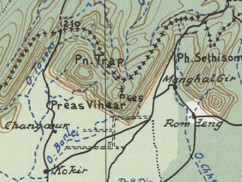
English: * Map showing the boundary between Thailand and Cambodia in Dangrek Mountains region. Relief shown by contours and spot heights.
|
| Date | Original from 1909; scan of a 2010 copy of 1962 reproduction |
| Source | https://nla.gov.au/nla.obj-234197782 |
| Author | H. Barrere, Editeur Géographe, 21 Rue de Bac, Paris / International Court of Justice |
| Other versions |
.png)
Licensing
[edit]
|
This work is in the public domain in its country of origin and other countries and areas where the copyright term is the author's life plus 70 years or fewer. | |
| This file has been identified as being free of known restrictions under copyright law, including all related and neighboring rights. | |
File history
Click on a date/time to view the file as it appeared at that time.
| Date/Time | Thumbnail | Dimensions | User | Comment | |
|---|---|---|---|---|---|
| current | 21:07, 30 July 2025 | | 820 × 615 (891 KB) | Paul 012 (talk | contribs) | File:Dangrek - Commission de Délimitation entre l'Indochine et le Siam (Annex I map).png cropped 89 % horizontally, 90 % vertically, 99 % areawise using CropTool with precise mode. |
You cannot overwrite this file.
File usage on Commons
The following page uses this file:
File usage on other wikis
The following other wikis use this file:
- Usage on en.wikipedia.org
- Usage on nl.wikipedia.org